
EAPP_2025 ArcGIS Pro Professional Exam: Domain Weights, Traps and a Six-Week Plan
EAPP_2025 is the exam behind the Esri Certified ArcGIS Pro Professional 2025 credential. In November 2026 it is 75 multiple-choice questions in 105 minutes, the voucher costs 325 USD, and Esri expects four years of applied ArcGIS Pro experience. This guide explains how the four weighted domains break down, where experienced analysts lose marks, and how to use a timed EAPP_2025 practice exam before you book the real one.
What does the ArcGIS Pro Professional exam expect you to do?
The exam is aimed at the person a GIS team turns to when a project goes beyond clicking through tools. Esri's own wording is that candidates apply advanced GIS concepts and knowledge to a project using best practices, and that they have at least four years of applied experience in ArcGIS Pro. Typical job titles in the Exam Information Guide are GIS specialist, GIS or geospatial analyst, senior GIS analyst and GIS manager. The questions are written for someone who has designed a geodatabase, finished a project end to end and had to explain a result to a person who does not care how it was made.
Esri lists the tasks a qualified candidate can do without help, and they read like a working week for a senior analyst: interpret fundamental spatial statistics, configure advanced visualisation for maps and scenes, explain how a geolocator works, use a network dataset to determine cost, script with ArcPy, author Arcade expressions, run advanced vector and raster analysis, design a geodatabase and work in a multiuser one, model surfaces, build ModelBuilder models, manage a mosaic dataset, choose a coordinate reference system, share items through a portal, author ArcGIS Pro Tasks, build charts, layouts and map series, and configure a data schema.
The guide is just as clear about what the exam does not ask. Production-quality cartography for a specialised industry, administering a relational database, building websites or apps with an SDK or the ArcGIS API for Python, network and systems administration, and administering an ArcGIS Online or portal organisation are all outside the qualified candidate's expected skills. If your day job is mostly one of those, expect some topics here to feel thin and others, such as geodatabase behaviour, to feel unexpectedly deep.
Esri also names the software the candidate should be familiar with: ArcGIS Pro 3.3, plus the Network Analyst, Spatial Analyst and 3D Analyst extensions. That matters for revision. Menu names and tool locations move between releases, so rehearse in a version close to 3.3 rather than the one a client's laptop happens to run.
EAPP_2025 at a glance: cost, length and format
Every figure below was read from Esri's exam page and the Exam Information Guide in November 2026. The matching ArcGIS Pro Professional syllabus page lists the same four domains. Prices and exam versions can change, so check Esri's page again the week you book.
| Item | Detail |
|---|---|
| Exam name | Esri Certified ArcGIS Pro Professional 2025 |
| Exam code | EAPP_2025 |
| Level | Professional |
| Questions | 75, multiple choice |
| Duration | 105 minutes |
| Voucher price | 325 USD (as of November 2026) |
| Language | English |
| Published | 30 January 2025 |
Seventy-five questions in 105 minutes leaves an average of 84 seconds each. A fact question can be answered in fifteen seconds, which buys time for the scenario items that describe a project, a dataset and a problem in several sentences. Read Esri's exam page for ArcGIS Pro Professional 2025 and the Exam Information Guide first; the exam follows the guide's skills list closely, and a candidate who has ticked every line of it has done most of the planning.
One more point from the guide: it presents the weights as an approximate size of each section, to be used as a checklist for finding gaps. Treat them as a way to decide where your hours go, not as a promise that exactly this share of questions will appear.
How are the four EAPP_2025 domains weighted?
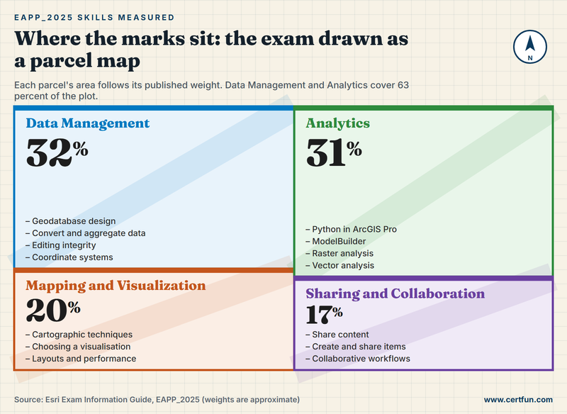
Esri splits the exam into four sections. Data Management is the heaviest at 32 percent, Analytics follows at 31 percent, Mapping and Visualization takes 20 percent and Sharing and Collaboration 17 percent. The first two together are 63 percent of the exam, so a candidate who is strong at maps and weak at geodatabases has the priorities the wrong way round. The picture below draws each domain as a land parcel whose area follows its weight.
Data Management (32 percent)
The skills list asks you to design a geodatabase for a set of project requirements, convert and aggregate data for a scenario, keep spatial and attribute data clean while editing, configure geodatabase behaviours and manage coordinate systems and projections. That is a lot of working knowledge in one heading: feature classes against feature datasets, subtypes and attribute domains, relationship classes, topology rules, how editing in a multiuser geodatabase differs from editing a file one, and which tool moves data between formats without losing behaviour. Coordinate systems sit here as well. You should be able to say when a project needs a projected rather than a geographic system, what a datum transformation is for, and why measuring area in the wrong projection returns a plausible but wrong number.
Analytics (31 percent)
Analytics is where Python, ModelBuilder and the analysis tools meet. The guide asks you to determine the use case for Python in ArcGIS Pro, to create and edit ModelBuilder models, to work out the workflow, data, tools, settings and parameters for a given analysis, and to identify procedures for raster and for vector analysis. Notice the verbs: determine, identify, given a scenario. You are rarely asked to type syntax. You are asked which tool, which setting or which sequence answers the question the scenario sets, and what would go wrong if a parameter such as the processing extent, the cell size or the snap raster were left alone.
Mapping and Visualization (20 percent)
This section covers advanced cartographic techniques, choosing the right visualisation for the data, configuring and optimising what you author, and setting Pro up so that visualisation stays fast. The guide's task list adds charts, infographics, layouts, map series and visualisation for scenes. A good test of readiness is whether you can say why a given symbology type suits a given field: a graduated colour ramp on raw counts, for example, misleads where a normalised rate would not, and the exam likes to check that you know the difference.
Sharing and Collaboration (17 percent)
The smallest section asks you to pick the most effective process for sharing content in a scenario, to identify the procedure for creating and sharing items, and to describe the basics of collaborative workflows. It sits beside the task list entries about authoring, sharing and retrieving items from a portal and using web content or services in an analysis. Portal administration is explicitly out of scope, so the questions come from the publisher's side of the fence: what you can share from Pro, in what form, and what the recipient will and will not be able to do with it.
Which EAPP_2025 domain costs experienced analysts the most marks?
Experienced users rarely lose marks where they expect to. The first trap is Data Management, because it is the area most analysts inherit rather than build. If a colleague designed the enterprise geodatabase years ago, you may use it daily without ever having chosen a subtype, written an attribute domain or decided a topology rule. The exam asks you to make those choices from a list of requirements, and the wrong answers are usually things that would work badly rather than things that would not work at all.
The second trap is Analytics for people who do most of their work through the interface. If you have never opened a Python window, the use cases for ArcPy will be a guess. If you have scripted for years but rarely built a model, the ModelBuilder questions about iterators, variables and model parameters will feel unfamiliar. Neither skill is hard; they are simply easy to avoid for years.
The third is subtler: depth across extensions. Network Analyst, Spatial Analyst and 3D Analyst are all named in the guide, and the candidate list includes using a network dataset to determine cost, performing surface modelling and managing a mosaic dataset. Someone who lives in vector editing all week may have touched none of those. Mark them on your gap list early, because they take a few evenings of hands-on work each rather than an hour of reading.
Mapping and Visualization is the domain candidates most often overrate, because they have made hundreds of maps. The exam is not asking whether your maps look good. It asks whether you can choose a technique for a stated purpose and configure it so that it performs, which is a narrower and more technical question.
ModelBuilder, ArcPy, Arcade and Tasks: which one does what?
Four different automation or authoring tools appear in the guide's skills list, and candidates mix them up more than any other topic. They solve different problems. ModelBuilder chains tools into a visual workflow you can run again, with no code. ArcPy is the Python package for scripting the same geoprocessing and much more, suited to loops, conditions and batch jobs across many datasets. Arcade is the expression language used inside labels, pop-ups, symbology and calculated fields, so it runs where the data is being displayed or calculated rather than as a separate script. ArcGIS Pro Tasks are guided, step-by-step workflows that lead a person through a process someone else designed.
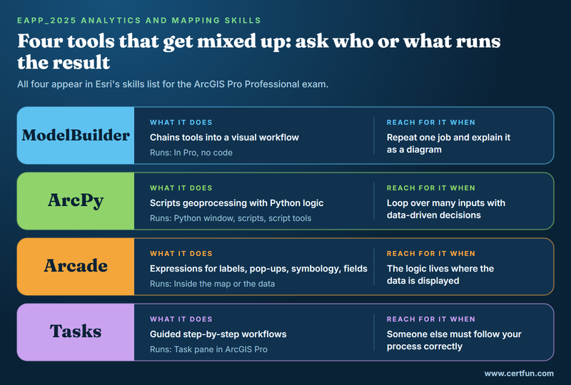
A fast way to sort them in an exam question is to ask who or what runs the result. If a person without GIS training must follow the steps, think Tasks. If the same chain of tools must be repeatable and easy to explain visually, think ModelBuilder. If it must iterate over many inputs with logic that depends on the data, think ArcPy. If the logic lives inside a label, a pop-up or a field calculation, think Arcade. Real projects mix all four, which is why the scenario items usually name an outcome and leave you to pick the tool.
Two cautions. First, do not treat Arcade as a second flavour of Python; the syntax and the places it runs are different, and a question that mentions an expression in a pop-up is almost never a Python question. Second, remember where ArcPy sits in the scope: the guide says use cases for Python in ArcGIS Pro, and separately places developing tools or apps with SDKs and the ArcGIS API for Python out of scope. Know what ArcPy can automate inside Pro, not how to build a web application.
What do EAPP_2025 scenario questions look like?
Esri writes professional-level items as small project briefs. Based on the skills list, expect themes like these.
- A schema to design. A utility wants pipes, valves and inspections stored so that valves cannot be placed away from a pipe and inspection types are limited to a fixed list. You pick the geodatabase features that enforce it.
- Data that arrives in a mess. Several agencies deliver parcels in different formats and coordinate systems. You choose the order of operations to merge, project and aggregate them without distorting the measurements.
- An analysis with the wrong answer. A suitability model returns results that cover the whole study area. The cause is a setting, such as an unset extent, a mismatched cell size or an unmasked input, and you name it.
- A map that is slow. A project with dozens of layers drags on every pan. You pick the changes that help: scale-dependent drawing, simpler symbology, or a more efficient source of data.
- A share that fails. A colleague cannot open a map you shared because it depends on data that was never part of the package. You identify what should have been shared, and how.
- A repeated chore. Fifty rasters need the same clip and reclassify. You decide between a model, a script and manual work.
None of these rewards memorised menus. Each assumes you have met the situation, or something close to it, in a sandbox, and can reason from the symptom to the cause.
A six-week EAPP_2025 plan that follows the weights
Six weeks assumes you already use ArcGIS Pro and can give six to eight focused hours a week. The time is shared in rough proportion to the weights, with the Analytics and Data Management weeks twice as long as the others.
- Week 1, the guide and a gap list. Read the Exam Information Guide in full and turn every task into a row in a spreadsheet, scored one to five for confidence. Install a version close to ArcGIS Pro 3.3 and check that the Network Analyst, Spatial Analyst and 3D Analyst extensions are licensed.
- Weeks 2 and 3, Data Management. Design a small geodatabase from a written brief with subtypes, domains, a relationship class and a topology. Edit it the way a team would, then repeat in a multiuser geodatabase if you can get access to one. Reproject the same data into three coordinate systems and compare the measured areas.
- Weeks 3 and 4, Analytics. Build one ModelBuilder model with an iterator and a model parameter, then rebuild the same job as an ArcPy script. Run a surface analysis, a network analysis and a raster workflow, and for each one write down which environment settings changed the result.
- Week 5, Mapping and Visualization, then Sharing. Produce a map series, a layout with a chart and a scene, and write two Arcade expressions. Then share a map, a layer and a project package, and open each as a different user to see what they receive.
- Week 6, timed practice. Sit a full 75-question practice exam in 105 minutes with no notes. Score every miss against the week 1 sheet, retrain the weakest two skills and sit a second set at the end of the week.
If you work in ArcGIS Pro all day, you can fold weeks 2 to 5 into three weeks by using your own projects as the sandbox. If most of your time goes to desktop editing in one narrow workflow, keep all six; the extension tasks are the ones that need the extra practice.
How should you use an EAPP_2025 practice test, and is the credential worth it?
A practice test is a measuring tool, not a textbook. Used too early it only confirms you have not studied. Used at the end of preparation it does three useful things. It calibrates pace, since scenario questions take far longer than the 84-second average. It shows which domain you overrate, and for many analysts that is Data Management. And it rehearses the pressure of a result that is simply pass or fail, so you practise answering every question and flagging the doubtful ones for a second look.
Look for a practice exam built from scenarios, covering the four domains in roughly the proportions above, with an explanation for every wrong option, so that each miss points back to a skill in Esri's list. CertFun is independent of Esri; its practice exam is a rehearsal written to Esri's published objectives, and hands-on work in ArcGIS Pro and Esri's own learning plan remain the main preparation. A good rule of thumb is to book once you have scored comfortably above your target twice in a row on different sets.
Is the credential worth 325 USD? For an analyst with several years behind them, it turns experience that is hard to describe into a line a hiring manager, a procurement reviewer or a partner programme can recognise. For someone still moving up from the associate level, the preparation itself may be worth more than the certificate, because the guide is a well-ordered list of what a senior ArcGIS Pro user should be able to do. One honest caveat: the 2025 in the name ties the exam to a software release, so check Esri's certification pages for the current version before you pay for a voucher.
Download the Exam Information Guide, score yourself against every task, and begin with the heaviest two domains. When your gap list is short, take a timed practice test and let the score, not the calendar, decide your exam date.
Frequently Asked Questions
How much does the EAPP_2025 exam cost and how long is it?
In November 2026 Esri listed the exam voucher at 325 USD. The exam has 75 multiple-choice questions to answer in 105 minutes, and it is offered in English. Esri can change prices, so confirm the figure on its exam page before you pay.
What are the EAPP_2025 domains and their weights?
Esri's guide lists four sections: Data Management at 32 percent, Analytics at 31 percent, Mapping and Visualization at 20 percent, and Sharing and Collaboration at 17 percent. The weights show the approximate size of each section, so use them to decide where to spend revision time.
What level of experience does the ArcGIS Pro Professional exam assume?
Esri expects at least four years of applied experience in ArcGIS Pro. It describes qualified candidates as proficient in best practices and able to design and implement workflows, troubleshoot, and lead complex GIS projects. Typical roles include GIS specialist, geospatial analyst, senior analyst and GIS manager.
Which ArcGIS Pro version should I study with for EAPP_2025?
The Exam Information Guide says a qualified candidate should be familiar with ArcGIS Pro 3.3, together with the Network Analyst, Spatial Analyst and 3D Analyst extensions. Practise on a version close to 3.3, because tool names and locations can shift between releases.
Does EAPP_2025 test Python programming?
It tests the use of Python in ArcGIS Pro, including ArcPy scripting and when it is the right tool, mostly through scenario questions. Developing apps or tools with SDKs and the ArcGIS API for Python is listed as beyond the qualified candidate's expected skills, so you do not need web development.
Is a CertFun practice exam made by Esri?
No. CertFun is independent of Esri, and its practice exam is not Esri material. It is a timed rehearsal written to Esri's published objectives, useful for finding weak areas. Hands-on ArcGIS Pro work and Esri's own learning plan remain the main way to prepare for the exam.
- Esri Certified ArcGIS Pro Professional 2025 |
- EAPP_2025 ArcGIS Pro Professional |
- ArcGIS Pro Professional Practice Test |
- ArcGIS Pro Professional Study Guide |
- ArcGIS Pro Professional Certification Mock Test |
- ArcGIS Pro Professional Mock Exam |
- Esri ArcGIS Pro Professional Practice Test |
- EAPP_2025 Syllabus |
- ArcGIS Pro Professional Certification Syllabus |
- ArcGIS Pro Professional Certification Cost


